Jinhao He

Jinhao He

Postgraduate Student

Robotics Lab @ School of Data and Computer Science @ SUN YAT-SEN UNIVERSITY

About Me

I am currently a master student in Computer Science and Technology at the School of Data and Computer Science(SDCS), Sun Yat-Sen University(SYSU) under the supervision of Prof. Cheng Hui. I received my bachelor’s degree in Software Engineering from SYSU in 2018.

Interests

  • Simultaneous Localization and Mapping(SLAM)
  • 3D Perception
  • Multi-Robot systems
  • Active SLAM
  • 3D Reconstruction
  • VR & AR

Education

  • MEng in Computer Science and Technology, 2018-2021

    SUN YAT-SEN UNIVERSITY

  • BEng in Software Engineering, 2014-2018

    SUN YAT-SEN UNIVERSITY

Projects

Ground and Aerial Collaborative Mapping in Urban Environments

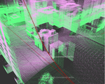
A system that uses heterogeneous platforms(cars and drones) mounted with 16-beam LiDARs and RGB cameras to build a 3D point cloud map of the environment.

Structure-awared Visual-LiDAR Odometry and Dense Mapping

A Visual-LiDAR SLAM system considering both point, line and planar constraints. This system employ multi-sensor fusion and dense mapping in a same pipeline, which is robust under degenerated scenarios.

Synthetic Data Generation for Multi-Robot SLAM

Time-synchronized simulation sensor data including LiDAR point cloud, stereo RGB images as well as IMU(Inertial Measurement Unit) data from multiple robots are recorded into ROS bags, which is sufficient for simulation tests for multi-robot SLAM systems.

LiDAR-based Collaborative Localization and Mapping

A system that uses multiple robots mounted with 16-beam LiDARs to build a 3D point cloud map of the environment.

Embedding Temporally Consistent Depth Recovery for Real-time Dense Mapping in Visual-inertial Odometry

Dense mapping is always the desire of simultaneous localization and mapping (SLAM), especially for the applications that require fast …

An Indoor Positioning System On Smart Phones

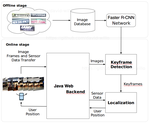
A system to help users to localize themselves in a shopping center using a smart phone. Image frames and gyroscope data are captured and upload to the server using an Android app.

Robust Visual Inertial Odometry With Consistent Sparsification

A hybrid solution integrating the features of adaptive sensor fusion, robust loss function, and consistent sparsification into a visual-inertial odometry (VIO) system, improving the system’s accuracy, robustness, and efficiency respectively.

Publications

(2020). Ground and Aerial Collaborative Mapping in Urban Environments. IEEE Robotics and Automation Letters (RA-L).

DOI

(2018). Embedding Temporally Consistent Depth Recovery for Real-time Dense Mapping in Visual-inertial Odometry. 2018 IEEE/RSJ International Conference on Intelligent Robots and Systems (IROS).

DOI

Patents

(2019). Method for calibrating camera and QR code in unmanned vehicle. CN201911267976.

(2019). Map fusion method suitable for sub-map with few overlapping parts. CN201910935188.

(2017). Quick depth restoring method for three-dimensional reconstruction. CN201711400434.

Contact

  • davidwillo@foxmail.com
  • No.132, Wai Huan Dong Road, Guangzhou Higher Education Mega Center, Guangzhou, Guangdong 510006